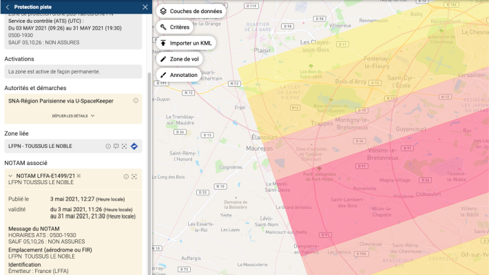
U-SpaceKeeper centralizes all data required for planning and carrying out drone operations, including zone restrictions, NOTAMs, temporary information and more.
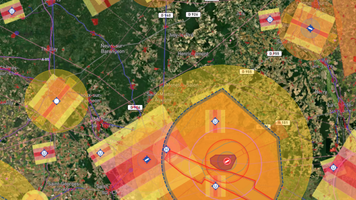
The information is displayed on interactive maps on the U-SpaceKeeper web and mobile platforms, and is available via public API, enabling drone operators and authorities to view geographic information and restrictions for a specific mission or a defined space.
Our Drone Aeronautical Information Management service automatically updates data using official data sources.
Authorities can define and add to the public API temporary and permanent restricted zones through their U-SpaceKeeper account.
| Cookie | Duration | Description |
|---|---|---|
| cookielawinfo-checbox-analytics | 11 months | This cookie is set by GDPR Cookie Consent plugin. The cookie is used to store the user consent for the cookies in the category "Analytics". |
| cookielawinfo-checbox-functional | 11 months | The cookie is set by GDPR cookie consent to record the user consent for the cookies in the category "Functional". |
| cookielawinfo-checbox-others | 11 months | This cookie is set by GDPR Cookie Consent plugin. The cookie is used to store the user consent for the cookies in the category "Other. |
| cookielawinfo-checkbox-necessary | 11 months | This cookie is set by GDPR Cookie Consent plugin. The cookies is used to store the user consent for the cookies in the category "Necessary". |
| cookielawinfo-checkbox-performance | 11 months | This cookie is set by GDPR Cookie Consent plugin. The cookie is used to store the user consent for the cookies in the category "Performance". |
| viewed_cookie_policy | 11 months | The cookie is set by the GDPR Cookie Consent plugin and is used to store whether or not user has consented to the use of cookies. It does not store any personal data. |
